Stevns Klint na wyspie Møn w Danii


Geologiczne Odkrycie: Wpływ Meteorytu Chicxulub
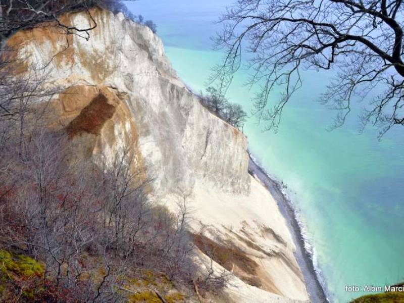
Stevns Klint to unikalny fragment ziemi, który stanowi doskonały przekrój przez historię Ziemi. Klif odsłania różnorodne warstwy geologiczne, z których najważniejsza jest ta datowana na koniec kredy, około 65 milionów lat temu, kiedy to w wyniku uderzenia meteorytu Chicxulub doszło do masowego wymierania życia na Ziemi. Wydarzenie to zmieniło oblicze planety, a jego skutki odczuwalne były przez miliony lat. Meteoryt uderzył w dno oceanu w okolicach półwyspu Jukatan w Meksyku, a jego zderzenie z Ziemią miało katastrofalne skutki, w tym wyginięcie około 50% ówczesnych gatunków, w tym dinozaurów.
Na Stevns Klint można podziwiać warstwy wulkaniczne i krzemienne, które są pozostałością tego dramatycznego wydarzenia. W szczególności dolna część klifu odsłania miękkie warstwy kredy, a także charakterystyczne wkładki z ciemnych buł krzemiennych, będące śladami chmur opadowych towarzyszących zderzeniu meteorytu z Ziemią. W górnej części klifu znajdują się odporniejsze płytowe wapienie danu, które tworzą charakterystyczną przewieszkę ponad kredą erodowaną przez morze Bałtyckie.

Niezrównany Widok i Malowniczy Krajobraz
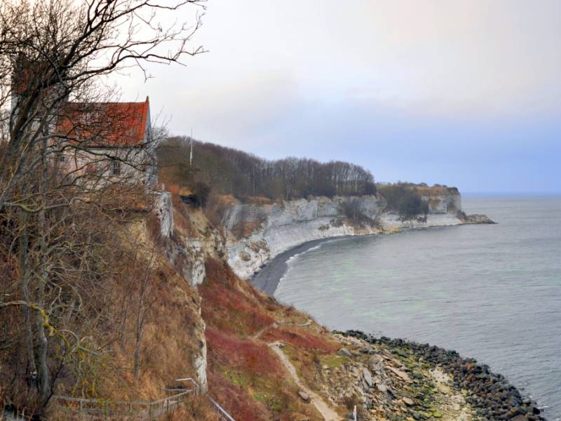
Jednym z głównych powodów, dla których Stevns Klint przyciąga turystów, jest zapierający dech w piersiach widok. Wysokość klifu, wynosząca około 40 metrów, zapewnia niezrównane widoki na Morze Bałtyckie i okoliczne wybrzeże. Kontrast białych, kredowych skał z głęboko niebieskim morzem oraz malachitową barwą wody przyciąga fotografów i miłośników natury z całego świata.
Klif jest także miejscem, w którym można spacerować, a liczne ścieżki i punkty widokowe umożliwiają kontemplowanie tego unikalnego krajobrazu. Wzdłuż wybrzeża biegną liczne ścieżki spacerowe, które pozwalają turystom zbliżyć się do klifu oraz zobaczyć to miejsce z różnych perspektyw.

Højerup Gl. Kirke – Kościół z Historii i Tragicznego Zdarzenia
Równie fascynującą atrakcją turystyczną Stevns Klint jest Højerup Gl. Kirke, czyli stary kościół z XIII wieku, który znajduje się na skraju klifu. Kościół ten był niegdyś jednym z centralnych punktów tej okolicy, ale w 1928 roku część kościoła – wraz z częścią wapiennej płyty klifu – runęła do morza. Choć sam kościół jest jednym z ważniejszych zabytków w Danii, to dramatyczna historia jego zawalenia się dodaje temu miejscu wyjątkowego charakteru.
Dziś kościół pozostaje popularnym celem pielgrzymek i turystów, a przy nim znajduje się punkt widokowy, z którego rozpościera się wspaniały widok na klif oraz morze. Obecność kościoła w tym malowniczym miejscu oraz jego historia sprawiają, że Stevns Klint to miejsce pełne symboliki, które na długo zapada w pamięć odwiedzających.

Atrakcje i Szlaki Spacerowe
Stevns Klint oferuje turystom nie tylko wspaniałe widoki, ale także możliwość aktywnego spędzenia czasu na świeżym powietrzu. Wzdłuż klifu przebiegają liczne ścieżki spacerowe, a także kilka punktów widokowych, które pozwalają na podziwianie tej geologicznej perełki z różnych perspektyw.
Punkty widokowe i schody na brzeg – tuż przy kościele Højerup znajdują się metalowe schody, którymi turyści mogą zejść w kierunku plaży i brzegów morza, by poczuć się jeszcze bliżej natury. Ponadto na lewo od kościoła rozciąga się ścieżka prowadząca w kierunku wysuniętej części klifu oraz latarni morskiej, którą warto zobaczyć, zwłaszcza o zachodzie słońca.

Informacje Praktyczne dla Zwiedzających
Godziny otwarcia:
- Stevns Klint to miejsce dostępne przez cały rok. Warto jednak odwiedzać to miejsce w cieplejszych miesiącach, kiedy warunki pogodowe sprzyjają spacerom po klifach i podziwianiu widoków.
- Kościół Højerup oraz tereny wokół są dostępne bezpłatnie przez całą dobę, chociaż w sezonie letnim mogą obowiązywać godziny otwarcia dla zwiedzających.
Bilety wstępu:
- Wstęp na klif oraz do kościoła Højerup jest bezpłatny. Warto jednak pamiętać, że w pobliżu znajduje się centrum edukacyjne, które oferuje dodatkowe informacje o historii klifu, a także wystawy dotyczące katastrofy meteorytowej i życia w kredzie.
- Możliwe jest także zakupienie biletów do specjalnych atrakcji, takich jak przewodniki po okolicach klifu czy specjalistyczne wykłady o geologii.
Dojazd:
- Stevns Klint znajduje się około 63 km na południe od Kopenhagi, co czyni to miejsce łatwo dostępnym dla zmotoryzowanych turystów. Dojazd do klifu zajmuje około godziny samochodem z centrum stolicy.
- Dojazd komunikacją publiczną: Z Kopenhagi kursują autobusy do Stevns, jednak może to być dość czasochłonne, ponieważ wymaga przesiadek w kilku miejscach.
Parking:
- Zamek parkingowy jest dostępny tuż przy kościele Højerup, gdzie znajduje się szlaban i miejsce parkingowe dla turystów. Parking jest płatny w sezonie turystycznym, a opłata wynosi około 30 DKK (około 4 EUR) za dzień.
- Istnieją także miejsca parkingowe w pobliżu latarni morskiej oraz punktów widokowych.
Wskazówki:
- Jeśli planujesz zejście na plażę, zabierz wygodne buty oraz wodoodporną odzież – woda może być chłodna, a teren wybrzeża jest dość śliski.
- Zaleca się zabranie ze sobą wody, szczególnie w cieplejsze dni, ponieważ obszar klifu jest dość otwarty na słońce, a dostęp do sklepów jest ograniczony.
- Jeżeli chcesz poznać szczegóły geologiczne tego miejsca, warto skorzystać z aplikacji mobilnych lub audioprzewodników, które są dostępne w wielu językach, w tym po angielsku.

Podsumowanie
Stevns Klint to nie tylko wspaniała atrakcja przyrodnicza, ale także pomnik przeszłości naszej planety, który opowiada historię o kosmicznych katastrofach, które miały wpływ na życie na Ziemi. Wspaniała geologia, zapierające dech w piersiach widoki, a także historyczne znaczenie miejsca sprawiają, że jest to jedno z najważniejszych miejsc do odwiedzenia na wyspie Møn. To miejsce, które łączy naukę, historię i piękno natury w jednym.


_large.jpg)